


Mention the word “exercise”, and jogging and cycling may be some of the popular sweat-inducing activities that come to mind. Then, there’s hiking. Not only is it a good cardio workout but it also helps to build muscle mass and of course, you get the benefit of sunshine a.k.a. vitamin D. Below is our selected list of 7 hiking trails in Negeri Sembilan worth exploring.
1) Kepayang Hill
Kepayang Hill a.k.a. Bukit Kepayang has several trails (over 30!) worth exploring. Each of these trails has its own difficulty level, depending on which one you choose. And interestingly enough, these trails have their own unique names (e.g. Big Pipe, Stone Wall, Old Ladder and Super Skyline). It’s a popular hiking spot among many novices and intermediate hikers. No matter which category you fall into, rest assured there are ropes on most of the trails to assist your climb. Reaching the peak can be challenging for some hikers since you have to encounter some steeper trails along the way. But it’s well worth the extra effort (hey, no pain, no gain, right?). Once you are at the top, you’ll be greeted with panoramic views of both Seremban and Seremban 2 and even the North-South Expressway.
Directions via Google Map: Click here

2) Mount Berembun
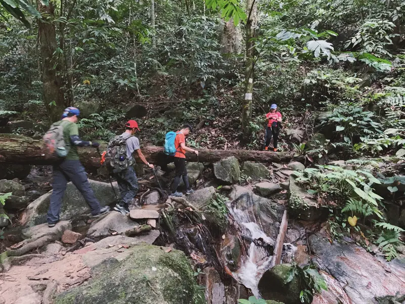
If you are up for a more challenging hike, you might want to explore Mount Berembun a.k.a. Gunung Berembun. Located near Kuala Klawang, the trail stretches approximately 12 km and it generally takes around 4-5 hours or so to complete. You will find plenty of large trees as well as various insects and of course, birds. The latter turns out to be one of the reasons why bird watchers love to hike Mount Berembun. There are waterfalls too (Lata Berembun) and if that’s not enough, you can hike further to visit the wreckage of a World War II’s Royal Air Force B-24 Liberator crash site at Gunung Telapak Buruk.
Directions via Google Map: Click here
3) Mount Angsi
Here’s another challenging route to test your stamina and endurance in Negeri Sembilan at Mount Angsi a.k.a. Gunung Angsi. It’s the third highest peak in the state, totalling 825m (2706 ft). There are two different loop trails that you can choose here: ascent from Bukit Putus or Ulu Bendul. It takes around 3-4 hours to reach the summit and keep in mind the trails can be steep and slippery. The latter is particularly true if you choose to climb after rain. Another thing worth noting here: It’s best to begin your hiking journey before 11 am and yes, you need to register first at the park ranger’s office and pay a nominal fee of RM5 per person.
Directions via Google Map: Click here

4) Bukit Bal
Bukit Bal may not be as popular as say, Bukit Kepayang but hikers still can look forward to several attractions. Suitable for beginners and intermediate hikers (around 2-3 hours worth of hike), the trails span 7.1 km and there are plenty of entry points to access Bukit Bal. You can start from S2 Height located at Rimbun Irama. Other entry points include Labu Batu 8, Jalan Bukit Nenas and Kg. Sebir. Speaking of attractions, there’s a Grand Canyon-like valley where you can take some photographs. Another attraction would be Twin Trees, which actually refers to the majestic twin Tualang trees.
Directions via Google Map: Click here

5) Bukit Kristal
Located in Sri Pulasan Park, the Bukit Kristal hiking journey falls under the easy-to-moderate difficulty level. But that doesn’t mean it’s a complete walk in the park since there are plenty of ascending — and yes, steep — trails along the way. Reaching the peak requires you to pass through not one but three different checkpoints. The first checkpoint begins at approximately 200m, followed by 300m and finally, 350m. You will find a power cable tower at every checkpoint and once you are at the top, you can get a view of flora and the Seremban town.
Directions via Google Map: Click here

6) Bukit Melati
A moderately easy path, even though hiking the Bukit Melati trails can be a little steep along the way. But fret not since there are ropes available to help with your climb. Bukit Melati itself consists of several small hills including Centipede Hill, Monkey Hill, Cobra Hill and Mosquito Hill. All trails are appropriately marked too so you don’t have to worry about getting lost during your hike. According to regular hikers, it would take around 1 1/2 to 2 hours to complete the loop.
Directions via Google Map: Click here

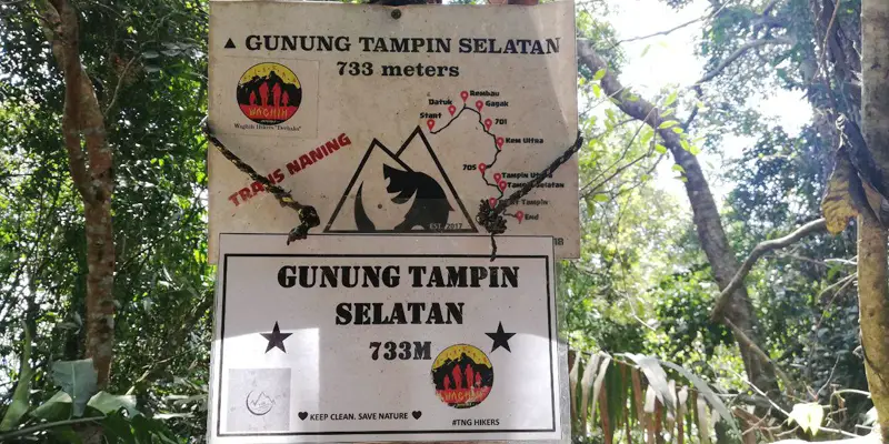
7) Gunung Tampin Selatan
To hike the 733m of Gunung Tampin Selatan would take around 2-3 hours totalling approximately 4.6 km. The hike itself is suitable for novices and intermediate hikers. You will encounter over 90 utility poles along the way, where your hiking journey would conclude at the TM telecommunication tower.
Directions via Google Map: Click here
Like this article? You might be interested in this one as well!

 in Sabah")


 to Gunung Tampin Selatan, it's time to sweat it out at these 7 hiking trails in Negeri Sembilan!)